Huwebes, Pebrero 2, 2012

Dota tournament

There is one certain Dota player who plays on any type of multiplayer wc3, wether it is bnet or some other illegal way of playing. His nicks online include of: Lilbuddah, Lilbudda, aznbob, bob, he is the biggest leaver and noob. He never finishes any game when he can, he always insults every person he comes accros, he is one of the people you hope you never meet in real life.

So all try to ignore this guy if you ever see him at all!

Wednesday, June 20, 2007


Ragequits and noobie comments!

Today's post is about one of the most annoying things you can come across in a game of dota! Some people when they are loseing a game, get too emotion when it comes down to a stupid video game, we get people swearing, insulting other and other strange things over the internet.

One main thing that grinds my gears is the fact that people make up excuses for loseing, "oh if only i had this, then we would be winning." God, yes of course you would be winning if you had you best character with the ultimate set up, but thats IF it happens, thats just like saying, Oh yeah, i would be winning if i used cheats. IF can mean alot of things, it is one of the lamest excuses in the history of any game, "If i did this i would of won!" Well i got news for you buddy, you didnt do it, so you lost, deal with it and dont cry about it, its a simple game that people over react about all the time.

Yes alot of us are guilty for little spirts of anger, but when comes down to something as simple as losing a game, thats when you know that its timeout for a week or two, go out and get a LIFE.

Next thing on my list is the amount of people that leave a game because they get annoyed for dieing first, or getting new people on there team or for things again, not going there way. Calm down, focus, do whatever, just do not quit in the middle of a game, it ruins the whole fun, games are made for fun, you can have fun while loseing, i have proved it myself, just because you think you are the best, doesnt mean you are, Get over yourself!!!!!!

Friday, June 15, 2007


Ban list

The Warcraft 3 banlist is a usefull little program which is easily downloaded. This program Lets you know when people leave a game, when friends enter battlenet, when friends enter a game and lots of other features.

Banlists main feature is Ban, while you are in the middle of a game and some leaves/lags out, a voice should come up saying "Leaver detected" from here you can chose to do one of two things, enter the command /banlast to add the person to your ban list, or ignore it. Before a game is started, banlist can bring up other peoples pings by the command /pingall, this then makes a beeping noise, and you the press Ctrl+V to paste the pings into chat.It also comes with an origin finder, you type in /fromall and it detects what region the player is from, like the /pingall command you need to Ctrl+paste the results.

One of the most useful parts of this program is the friendslist part, once you log into battlenet, it loads your friends list. If you wanted to follow a mate into a game, all you have to do is get the mate to join a game, when he joins, banlist will make a beep noise, from here all you do is Ctrl+V the text into the game name section, and there you have it, in the same game withing seconds.

In all, banlist is used by most battlenet users of warcraft 3, wether it be dota/melee/td maps, best thing to do is, have a steady connection and dont get too annoyed if you dont want to be tagged as a Leaver or lagger.

Wednesday, June 13, 2007


Ogre Magi Strat!

Greetings all, i am going to post my item strat for the Hero Ogre Magi. Ogre Magi is a basic hero which most people will say is played based on luck. The Ogre Magi is a Melee intel based hero which is something you dont come up against most of the time. From the first level, you can chose from either 3 spells, Fireblast (stun and damage), Ignite (Aoe fire damage over time and slow) and Bloodlust (increases attack and move speed). At level 6 you can choose to get your "ultimate" spell 'Multicast' (chance on spell hit to cast the same spell multiple times)

Order of which i learn skills
Level 1: Fireblast
Level 2: Ignite
Level 3: Fireblast
Level 4: Ignite
Level 5: Fireblast
Level 6: Multicast
Level 7: Fireblast
Level 8: Ignite
Level 9: Ignite
Level 10: Bloodlust
Level 11: Multicast
Level 12: Bloodlust
Level 13: Bloodlust
Level 14: Bloodlust
Level 15: Attribute +
Level 16: Multicast
Level 17 - 25: Attribute +

When it comes down to getting items, i cant tell you when exactly you can buy them, depends on you income flow, 5 v 5 game, less gold to start with, 3 v 3 more gold then 5 v 5, things like that. My main order of getting items is:

Item 1: Boots of speed
Item 2: Robe of Magi
Item 3: Staff of wizardry
Item 4: Void stone
Item 4: Eul's scepter of divinity Recipe
Item 5: Robe of Magi
Item 6: Sobi mask
Item 7: Quaterstaff (at this point you should get oblivion staff)
Item 8: Guinsoo's scythe of Vyse recipe
Item 9: Boots of Travel recipe
Item 10: Messerschimidts Reaver
Item 11: Vitality Booster
Item 12: Heart of Tarrasque recipe

I have never needed to get anymore then these in a game, if you get to a point like this, just buy what you think is right :)

------------------------------------------------------------------------------------------

------------------------------------------------------------------------------------------

Tuesday, June 12, 2007


What not to do!

While playing Dota on the internet, the best thing what not to do is, DO NOT DRAG THE GAME OUT. If you can finish the game, then finish it, dont walking around and kill Roshan when you have mega creeps, dont feed off heros just to get your "perfect" item spec.

Many players who do this on the internet end up on a Banlist, my person banlist has about 100 people on it on the server U.S West that do not finish the game because they think because they are winning, they can do whatever the heck they want to do. Well guess what? YOUR WRONG, the most annoying thing that can happen is, a 30 minute game turning into a 1 hour game so you dont get time to play another. It is not fun and it is basically the worst thing in the history of the Dota maps!

To all those idiots that do this, learn to play, because you are in control of a game, doesnt make you god, finish the game off before you get kicked from every damned game that you want to join!!

Thats my personal opinion, come back for more info, tips and fire offs coming soon :D

------------------------------------------------------------------------------------------

------------------------------------------------------------------------------------------

Monday, June 11, 2007


Welcome!

Hello fellow Warcraft 3 players! this website will include some hints, tips, strats, information and things that really annoy me and most others when you play the game Dota on the internet or with friends on LAN.

This site will try to be updated daily for your every day usage and to keep you up to date with all current versions of the map. So come back on a regular basis to have a look at what i can offer you guys when it comes to this very popular Frozen Throne map.

Martes, Enero 31, 2012

PAGSANJAN FALLS

Pagsanjan Falls (indigenous name: Magdapio Falls) are one of the most famous waterfalls in the Philippines. Located in the province of Laguna, the falls are one of the major tourist attractions in the region. The falls are reached by a river trip on dugout canoe known locally as shooting the rapids, originating from the municipality of Pagsanjan.The town itself dates from early Spanish times and lies at the confluence of two rivers, the Balanac and the Bumbungan.

Contents

 []

[] Location


The visible and taller second drop
The waterfalls are actually located within the boundaries of Cavinti, Laguna but access by a boat originates from the town of Pagsanjan. A move by the ruling body of the town of Cavinti was submitted to the Sangguniang Bayan (legislature of municipalities in the Philippines) on February 10, 2009 proposing the renaming of the falls to Cavinti Falls.

[] National Park

The falls and gorge were declared as National Park with Proc. 392 on March 29, 1939 and Proc. 1551 on March 31, 1976. The Pagsanjan Gorge National Park covers an area of 152.64 hectares (377.2 acres).[4]

[] Legend

According to history, the Pagsanjan Falls is rich in legendary lore. Long, long ago, recounts one legend, there were no falls. There were only the foliaged highlands, the twin rivers, called Bumbungan and Balanac, and the alluvial delta (where the town of Pagsanjan now nestles). On the eastern bank of the Bumbungan River lived two old brothers named Balubad and Magdapio. For many years, the two brothers enjoyed a rustic life of peace and happiness. But one day calamity struck. A terrible drought brought ruin and death. No rains came for successive months. The soil became dry as tinder. The blooming flowers and food plants withered and died. The birds, deer, wild hogs, monkeys, and other animals disappeared. The rivers, creeks, and mineral springs dried up. Not a single drop of life-giving rain fell from heaven.

Going upstream to the falls then shooting the rapids downstream through the verdant tropical gorge
Balubad and Magdapio suffered immensely. Day and night, they prayed for rain, but the gods did not heed their prayers. The older and weaker of the two brothers, Balubad, died of thirst. Magdapio, with a sorrowing heart, buried him on the slope of the mountain overlooking the river delta. This mountain is now called Balubad.
Left alone in a waterless world, Magdapio agonizingly trekked to the upper region of the arid riverbed. He reached the high rocky cliffs, after an arduous journey. To his utter disappointment, he found no water.
"Ye gods!" he sobbed bitterly, "Where is the water?" In despair, he angrily hurled down his big cane among the rocks.
Suddenly, a spring bubbled on the spot where the cane fell. Rapidly it grew bigger. The fresh waters roared down the canyon walls, soon becoming a booming waterfall. Amazed at the miracle, Magdapio fell on his knees and thanked the gods. He drank the cool water until he felt new energy surging in his blood. Thus emerged the falls of Pagsanjan.

BORRACAY

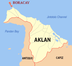
Boracay is an island of the Philippines located approximately 315 km (196 mi) south of Manila and 2 km off the northwest tip of Panay Island in the Western Visayas region of the Philippines. Boracay Island and its beaches have received awards numerous times. Boracay was awarded in the "Travelers' Choice 2011" by TripAdvisor as the second best beach (out of 25) in the world.[2] Boracay made a debut appearance on the Top 10 Islands list in the Travel + Leisure travel magazine World's Best Awards 2011, ranking fourth.[3][4][5]
The island comprises the barangays of Manoc-Manoc, Balabag, and Yapak (3 of the 17 barangays which make up the municipality of Malay), and is under the administrative control of the Philippine Tourism Authority in coordination with the Provincial Government of Aklan.

Contents

[] History

Boracay was originally home to the Ati tribe. Boracay is part of Aklan Province, which became an independent province on April 25, 1956.
In the late 1800s the island was "discovered" by Sofia Gonzales Tirol. She and her husband Lamberto Hontiveros Tirol, a town judge on nearby Panay island, took ownership of substantial properties and began to cultivate[7] and develop the island.[8]
Boracay Island was relatively unknown until tourism began to develop in the 1970s,[9] after the movie Too Late the Hero was filmed on locations in Boracay and Caticlan.[10] In the 1980s, the island became popular as a budget destination for backpackers,[6]an by the 21st century, had grown to become one of the major tourist destinations in the Philippines.Many tourist visit in boracay.

[] Geography


Location of Boracay above Panay Island.
Boracay Island is located off the northwest corner of Panay Island, and belongs to the Western Visayas island-group, or Region VI, of the Philippines. The island is approximately seven kilometers long, dog-bone shaped with the narrowest spot being less than one kilometer wide, and has a total land area of 10.32 square kilometers.
South-facing Cagban Beach is located across a small strait from the jetty port at Caticlan on Panay island, and the Cagban jetty port serves as Boracay's main entry and exit point during most of the year. When wind and sea conditions dictate, east-facing Tambisaan Beach serves as an alternative entry and exit point.[citation needed]
Boracay's two primary tourism beaches, White Beach and Bulabog Beach, are located on opposite sides of the island's narrow central area. White Beach faces westward and Bulabog Beach faces eastward. The island also has several other beaches.
White Beach is the main tourism beach. It is about four kilometers long and is lined with resorts, hotels, lodging houses, restaurants, and other tourism-related businesses. In the central portion, for about two kilometers, there is a footpath known as the Beachfront Path separating the beach itself from the establishments located along it. North and south of the Beachfront Path, beachfront establishments do literally front along the beach itself. Several roads and paths connect the Beachfront Path with Boracay's Main Road, a vehicular road which runs the length of the island. At the extreme northern end of White Beach, a footpath runs around the headland there and connects White Beach with Diniwid Beach.
Bulabog Beach, across the island from White Beach, is the second most popular tourism beach on the island and Boracay's main windsurfing and kiteboarding area.
Boracay is divided, for land use and conservation purposes, into 400 hectares of preserved forestland and 628.96 hectares of agricultural land.[11][12][13][14]

[] Climate


Map of Boracay Island.
Weather in Boracay is generally divided into two seasonal weather patterns known locally as the Amihan and Habagat seasons. In the Visayan language, Amihan means a cool northeast wind, and Habagat means west or southwest wind; south-west monsoon.[15] The Amihan season is characterized by moderate temperatures, little or no rainfall, and a prevailing wind from the east. The Habagat season is characterized by hot and humid weather, frequent heavy rainfall, and a prevailing wind from the west.[citation needed]
On Boracay, the main indicator of the switch between the Amihan and Habagat seasonal patterns is the switch in wind direction. In most years this transition is abrupt and occurs overnight. In some years there is a period of perhaps a week or two where the wind will switch between Amihan and Habagat patterns several times before settling into the pattern for the new season. As a general rule of thumb, Boracay will be in the Amihan weather pattern from sometime in September or October to sometime in May or June and in the Habagat weather pattern for the remainder of the year. These dates can vary in individual years, though.[citation needed]
Daytime temperatures on Boracay generally range from 77-90°F (25-32°C) from the beginning of the Amihan season into February or March, and increase to the 82-100°F(28-38°C) range with the onset of the Habagat season.[16] During Tropical Storm periods, temperatures can fall below 68°F (20°C). Tropical Storms can impact Boracay at any time of year, but are most likely to be seen during the Habagat season.[17]

[] Education

Among schools on the island is the independent Boracay European International School that teaches from Nursery through to Grade 9 and prepares students for the [[International Baccalau

[] Tourism


Puka Beach, Boracay where the rare Puka shells are found.
Partly because of its wind and weather patterns, tourism in Boracay is at its peak during the Amihan season. During Amihan, the prevailing wind blows from the east. Boracay's main tourism area, White Beach, is on the western side of the island and is sheltered from the wind. During the Amihan season, the water off White Beach is often glassy-smooth. On the eastern side of the island, hills on the northern and southern ends of the island channel the Amihan season wind from the east onshore, onto Bulabog Beach in the central part of the island's eastern side. This makes the reef-protected waters off that beach ideal for windsurfing and kiteboarding / kitesurfing.
In June 2011, it was reported that a real estate development group led by Andrew Tan had earmarked P20 billion to develop tourism estates "featuring an integrated, master-planned layout and world-class resort offerings and amenities" in Boracay and Cavite. The planned Boracay project, Boracay Newcoast, involves four hotels with 1,500 rooms, a plaza and entertainment center.[18]

[edit] Leisure activities

Leisure activities available on or near Boracay include scuba diving, snorkeling, windsurfing, kiteboarding, cliff diving, and beach relaxation.
Boracay is the site of a 18-hole par 72 golf course designed by Graham Marsh.[citation needed] In addition, as of 2010, Boracay has in excess of 350 beach resorts offering more than 2,000 rooms ranging in quality from five-star to budget accommodation.[citation needed]
In addition, Boracay offers a wide range of restaurants, bars, pubs, and nightclubs.

[] Events

Boracay is one competitive venue for the Asian Windsurfing Tour,[19] with the week-long Boracay International Funboard Cup competition usually held in January on Bulabog Beach. In 2010, the event dates are January 25 – 31.[20] CNNGo, a division of CNN focused on travel/lifestyle/entertainment, selected the Boracay International Funboard Competition on the weekend of January 22–24 as one of its 52 weekend recommendations for 2010.[21]
The well-known Ati-Atihan Festival takes place each January in Kalibo on nearby Panay island. A much smaller Ati-Atihan festival is celebrated on Boracay, usually in the second or third week of January.[citation needed]
Dragon boat races are held annually on Boracay under the auspices of the Philippine Dragon Boat Federation, with teams coming from around the Philippines and from other Asian nations to compete. The races usually take place sometime in April or May.[citation needed]
The Boracay Open Asian Beach Ultimate Tournament, an ultimate frisbee event, has been held annually since 2003, usually during summer.[22

TAAL VULCANO

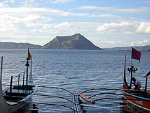
Taal Volcano is a complex volcano located on the island of Luzon in the Philippines. Historical eruptions are concentrated on Volcano Island, an island near the middle of Lake Taal. The lake partially fills Taal Caldera, which was formed by powerful prehistoric eruptions between 140,000 to 5,380 BP.[1] Viewed from Tagaytay Ridge, Taal Volcano and Lake presents one of the most picturesque and attractive views in the Philippines.[2] It is located about 50 km (31 mi) south of the capital of the country, the city of Manila.
The volcano had several violent eruptions in the past causing loss of life in the island and the populated areas surrounding the lake, with the death toll estimated at around 5,000 to 6,000. Because of its proximity to populated areas and its eruptive history, the volcano was designated a Decade Volcano, worthy of close study to prevent future natural disasters. It is one of the active volcanoes in the Philippines and part of the Pacific ring of fire.

Geography

Taal Volcano and Lake are wholly located in the province of Batangas. The northern half of Volcano Island falls under the jurisdiction of the lake shore town of Talisay, and the southern half to San Nicolas. The other towns that encircle Taal Lake include Tanauan, Talisay, Laurel, Agoncillo, Santa Teresita, Alitagtag, Cuenca, Lipa, Balete and Mataas na Kahoy.[3]
Permanent settlement in the island is prohibited by the Philippine Institute of Volcanology and Seismology or PHIVOLCS, declaring the whole Volcano Island as a high-risk area and a Permanent Danger Zone (PDZ).[4] Despite the warnings, poor families have settled on the island, risking their lives, earning a living by fishing and farming crops from the rich volcanic soil.[5][6][7][8]

[] Recent activity

Although the volcano has been quiet since 1977, it has shown signs of unrest since 1991, with strong seismic activity and ground fracturing events, as well as the formation of small mud pots and mud geysers on parts of the island. The Philippine Institute of Volcanology and Seismology (PHIVOLCS) regularly issues notices and warnings about current activity at Taal, including ongoing seismic unrest.[9]

[] 2011

  • 5 Jul. Alert Level was lowered from 2 to 1 after 11 weeks (April 9) of increased activity.
  • 1 Jun. Alert Level 2. Volcanic earthquakes (24 hrs) = 22. (2) Intensity II earthquakes in the eastern sector of volcano accompanied by rumbling sounds. Bubbling activity observed in the middle of Main Crater Lake.
  • 31 May. Alert Level 2. Volcanic earthquakes (24 hrs) = 31. (1) Intensity I and (2) Intensity II earthquakes, NE & SE sector of volcano accompanied by rumbling sounds.
  • 30 May. Alert Level 2. Volcanic earthquakes (24 hrs) = 115. (1) Intensity I, (9) Intensity II, (1) Intensity III, and (1) Internsity IV earthquakes, NE, SW & SE sector of volcano accompanied by rumbling sounds.
  • 29 May. Alert Level 2. Volcanic earthquakes (24 hrs) = 10.
  • 28 May. Alert Level 2. Volcanic earthquakes (24 hrs) = 6. Magma has been intruding towards the surface, as indicated by continuing high rates of CO2 emissions in the Main Crater Lake and sustained seismic activity. Field measurements on 24 May 2011 show lake temperatures slightly increased, pH values slightly more acidic and water levels 4 cm higher. A ground deformation survey conducted around the Volcano Island 26 April - 3 May 2011 showed that the volcano edifice inflated slightly relative to the 05-11 April 2011 survey.[10]
  • 22 May. Alert level 2. Volcanic earthquakes (25 hrs) = 5.[11]
  • 10 Apr. Alert Level 2. The main crater, Daang Kastila Trail, and Mt Tabaro are strictly off-limits to the public because sudden hazardous steam-driven explosions could occur. Breathing air with high concentration of gases can be lethal to humans, animals and can even damage vegetation, the agency warned[12]

[] 2010

  • 8 June. PHIVOLCS raised the volcano status to Alert Level 2[13] (scale is 0-5, 0 referring to No Alert status), which indicates the volcano is undergoing magmatic intrusion which could eventually lead to an eruption. PHIVOLCS reminds the general public that the Main Crater remains off-limits because hazardous steam-driven explosions may occur, along with the possible build-up of toxic gases. Areas with hot ground and steam emission such as portions of the Daang Kastila Trail are considered hazardous.[14]
  • 11–24 May. Crater lake temperature increased by 2-3°C. The composition of Main Crater Lake water has shown above normal values of Mg/Cl, SO4/Cl and Total Dissolved Solids. There has been ground steaming accompanied by hissing sounds on the northern and northeast sides of the main crater.
  • 26 April. Volcanic seismicity had increased.

[]

di 2009

  • 20 July. National Disaster Coordinating Council (NDCC) executive officer Glenn Rabonza warned that although there were no volcanic quakes detected at Taal since the detection of nine volcanic quakes from June 13 to July 19, and there had been no steaming activity monitored since last recorded on June 23, Phivolcs Alert stands at Level 1, warning that Taal’s main crater is off-limits to the public because steam explosions may suddenly occur or high concentrations of toxic gases may accumulate.[citation needed]
Taal Volcano provides a picturesque view from Tagaytay City.

[] 2008

  • 28 August. PHIVOLCS notified the public and concerned authorities that the Taal seismic network recorded ten (10) volcanic earthquakes from 5:30 AM to 3 PM. Two (2) of these quakes that occurred at 12:33 and 12:46 PM, were both felt at intensity II by residents at barangay Pira-piraso. These quakes were accompanied by rumbling sounds. The events were located northeast of the volcano island near Daang Kastila area with depths of approximately 0.6 km (12:33 PM) and 0.8 km (12:46 PM)" [15]

[] Geological history

Taal Volcano is part of a chain of volcanoes along the western side of the edge of the island of Luzon, which were formed by the subduction of the Eurasian Plate underneath the Philippine Mobile Belt. Taal Lake lies within a 25–30 km caldera formed by four explosive eruptions between 500,000 and 100,000 years ago. Each of these eruptions created extensive ignimbrite deposits, reaching as far away as where Manila stands today.[citation needed]
Since the formation of the caldera, subsequent eruptions have created another volcanic island, within the caldera, known as Volcano Island. This island covers an area of about 23 square kilometres (8.9 sq mi), and consists of overlapping cones and craters. Forty-seven different cones and craters have been identified on the island.[16]

[] Eruption history

There have been 33 recorded eruptions at Taal since 1572. The first eruption of which there is any record occurred in 1572, the year the Agustinian friars founded the town of Taal on the shores of the lake (on what is now San Nicolas, Batangas). In 1591, another mild eruption took place featured by great masses of smoke issuing forth from the crater. From 1605 to 1611, the volcano displayed such great activity that Father Torna de Abreu had a huge cross of anubing wood erected on the brink of the crater.[17]
The dormant Binintiang Malaki (Big Leg) Crater is the center of the 1707 & 1715 eruption.
Between 1707 and 1731, the center of activity shifted from the Main Crater to other parts of Volcano Island. The eruptions of 1707 and 1715 occurred in Binitiang Malaki crater (the cinder cone visible from Tagaytay). Minor eruptions also emanated from the Binintiang Munti crater on the westernmost tip of the island in 1709 and 1729. A more violent activity happened on September 24, 1716, when the whole southeastern portion of the crater (Calauit), opposite Mount Macolod, was blown out. The 1731 eruption off Pira-Piraso or eastern tip of the island created an island.[18] No studies had been done to determine whether Napayon or Bubuin Island was formed in the eruption, or just a pumice raft.
Activity returned to the Main Crater in 1749, and it was remembered for being particularly violent (VEI = 4). Then came the great 200-day eruption of 1754, the greatest eruption of Taal which is described below.[16][17]
Taal remained quiet for 54 years except for a minor eruption in 1790, not until March 1808 did another big eruption occur. While this outbreak was not as violent as the one in 1754, the immediate vicinity were covered with ashes to a depth of 84 centimetres (33 in). It brought great changes in the interior of the crater, according to chroniclers of that time. Before, the bottom looked very deep and seemed unfathomable, but at the bottom, a liquid mass was seen in continual ebullition. After the eruption, the crater had widened and the pond within it had been reduced to one-third and the rest of the crater floor was higher and dry enough to walk over it. The height of the crater walls has diminished and near the center of the new crater floor, a little hill that continually emitted smoke. On its sides were several wells, one of which was especially remarkable for its size.[18]
On July 19, 1874, an eruption of gases and ashes killed all the live stock on the island. From November 12 to 15, 1878, ashes ejected by the volcano covered the entire island. Another eruption took place in 1904 as a result of which a new outlet was formed in the southeastern wall of the principal crater. The last eruption from the Main Crater was in 1911 which obliterated the crater floor creating the present lake. In 1965, a huge explosion sliced off a huge part of the island, moving activity to a new eruption center, Mount Tabaro. Eruptions have also been recorded in 1634, 1635, 1641, 1645, 1790, 1825, 1842, 1873, 1885, 1903, 1966, 1967, 1968, 1969, 1970, 1976 and 1977.[16][19] Some of the major eruptions are described below:

[] The 1754 eruption

Taal Volcano's greatest recorded eruption occurred in 1754 which lasted from May 15 to December 1. The following is the narrative account of Fr. Buencuchillo, parish priest of Sala, and stationed at Taal at that time:
On May 15, 1754, at about 9 or 10 o'clock in the night, the volcano quite unexpectedly commenced to roar and emit, sky-high, burning flames intermixed with glowing rocks which, falling back upon the island and rolling down the slopes of the mountain, created the impression of a large river of fire. During the following days there appeared in the lake a large quantity of pumice stone which had been ejected by the volcano. Part of these eject had also reached the hamlet of Bayuyungan and completely destroyed it.
The volcano continued thus until June 2, during the night of which the eruption reached such proportions that the falling ejecta made the entire island appear to be on fire, and it was even feared that the catastrophe might involve the shores of the lake. From the said 2nd of June until September 25, the volcano never ceased to eject fire and mud of such bad character that the best ink does not cause so black a stain.
During the night of September 25, the fire emitted was quite extraordinary and accompanied by terrifying rumblings. The strangest thing was, that within the black column of smoke issuing from the volcano ever since June 2, there frequently formed thunderstorms, and it happened that the huge tempest cloud would scarcely ever disappear during two months.
At daybreak of September 26 we found ourselves forced to abandon our dwelling for fear lest the roofs come down upon us under the weight of ashes and stones which had fallen upon them during that hapless night. In fact, some weaker buildings collapsed. The depth of the layer of ashes and stones exceeded two "cuartas" (45 centimeters), and the result was that there was neither tree nor other plant which it did not ruin or crush, giving to the whole region an aspect as if a devastating conflagration had swept over it. After this the volcano calmed down considerably, though not sufficiently to offer any prospect of tranquility.
During the night of November 1, Taal resumed its former fury, ejecting fire, rocks, sand, and mud in greater quantities than ever before. On November 15, it vomited enormous boulders which rolling down the slopes of the island, fell into the lake and caused huge waves [note(added by Saderra Maso): The waves mentioned were most probably due to the earthquake rather than to the falling rocks]. The paroxysms were accompanied by swaying motions of the ground which caused all the houses of the town to totter. We had already abandoned our habitation and were living in a tower which appeared to offer greater security; but on this occasion we resolved that the entire population retire to the Sanctuary of Casaysay, only the "Administrator" and myself to remain on the spot.
At 7 in the evening of November 28 occurred a new paroxysm, during which the volcano vomited forth such masses of fire and ejecta that in my opinion, all the material ejected during so many months, if taken together, would not equal the quantity which issued at the time. The columns of fire and smoke ascended higher than ever before, increasing every moment in volume, and setting fire to the whole island, there being not the smallest portion of the latter which was not covered by the smoke and the glowing rocks and ashes. All this was accompanied by terrific lightning and thunder above, and violent shocks of earthquakes underneath. The cloud of ejecta, carried on by the wind, extended itself toward west and south with the result that we saw already some stones fall close to our shore. I, therefore, shouted to all those who were still in the town to take to flight and we all ran off in a hurry; otherwise we would have been engulfed on the spot; as the waves of the angry lake began already to flood the houses nearest to the beach.
We left the town, fleeing this living picture of Sodom, with incessant fear lest the raging waters of the lake overtake us, which were at the moment invading the main part of the town, sweeping away everything they encountered. On the outskirts of the town, I came upon a woman who was so exhausted by her burden of two little children and a bundle of clothing that she could proceed no farther. Moved by pity, I took one of the toddlers from her and carried him, and the little indio who has been wailing while in the arms of his mother, stopped short when I took him into mine and never uttered a sound while I was carrying him a good piece of the way.
Having reached a secure place on elevated ground at a distance of about half a league (2 kilometers) from the town, we halted in a hut to rest a little and take some food. From this spot the volcano could be contemplated with a little more serenity of mind. It still continued in full fury, ejecting immense masses of material. Now I also observed that the earth was in continuous, swaying motion, a fact which I had failed to notice during the excitement and fear of the flight.
Shortly afterward the volcano suddenly subsided almost suddenly; its top was clear and apparently calm. We, therefore, returned on the following day, the 29th, to the town with the intention of surveying the havoc wrought during the preceding night.
The 29th had dawned calm, but while we were still trying to persuade ourselves that the tragedy was over and the volcano had exhausted its bowels, at about 8 o'clock, we heard a crash and then I noticed that smoke was rising from the point of the island that looks towards east. The smoke spread very gradually as far as the crater of the volcano, while there were many whiffs issuing from points in the direction of another headland. I realized that the island had opened in these places and fearing that, if a crater should open below the water, an explosion might follow, much more formidable than the preceding ones, I mounted a horse and retired permanently to the Sanctuary of Caysasay.
Between 3 and 4 o'clock in the afternoon of the said 29th, it began to rain mud and ashes at Caysasay [12 miles from the volcano] and this rain lasted three days. The most terrifying circumstance was that the whole sky was shrouded in such darkness that we could not have seen the hand placed before the face, had it not been for the sinister glare of incessant lightnings. Nor could we use artificial light as this was extinguished by the wind and copious ashes which penetrated everywhere. All was horror those three days, which appeared rather like murky nights and we did not occupy ourselves with anything but see to it that the natives swept off the roofs the large quantities of ashes and stones which kept on accumulating upon them and threatened to bring them down upon us, burying us alive beneath their weight. But fearing that even these precautions might prove unavailing, we 3 Europeans - viz. Fr. Prior, the Alcalde, and myself - the only ones who were at the time in the Convento of Caysasay, took refuge on the landing of the stairs; as the safest place, and awaited there whatever God might dispose with regard to us. To all this was added incessant thunder and lightning, and it really looked as if the world was going to pieces and its axis had been displaced.
During the night of the 30th we had not a moment of repose, as every moment we heard the loud crush of houses collapsing under of stones, mud, and ashes piled upon them, and feared that the turn of the convento and the church of Casasay would come in next. Shortly before daybreak of December 1 there was a tremendous crash as if the house were coming down on our heads: the roof of the apse of the church had caved in! Not long afterward, the roof of their kitchen gave away with a thud. Both were tile roofs.
The first of December broke somewhat clear and our eyes contemplated everywhere ruins and destruction. The layer of ashes and mud was more than 5 spans [1.10 m] thick, and it was almost a miracle that the roof of the church and convento sustained so great a weight. We caused the bulk of the material to be removed, while new continued to fall on that day and the following, on which latter the direction of the wind changed, carrying the ejecta toward Balayan. On the 3rd and 4th we had a formidable typhoon, and thereafter the volcano quieted down.
Soon afterward I resolved to visit my town of Taal; nothing was left of it except the walls of the church and convento. All the rest, the government house, the walks of the rope factory, the warehouse, everything was buried beneath a layer of stones, mud, and ashes more than 10 spans [2.20 m] thick; only here and there could be seen an upright post, the only remnant of a comfortable dwelling. I went down to the river and found it completely filled up, with a boat belonging to the alcalde and many of private persons buried in the mud. After incredible efforts I finally succeeded in unearthing in what had once been the church and sacristy, the chests which contained the sacred vestments and vessels. Nearly all of them were demolished by the rocks and beams which had fallen upon them, and filled with foul-smelling mud that had ruined or disfigured their contents. With the aid of some natives of Bauang, I likewise recovered some property from among the ruins of the convento.
Twelve persons are known to have perished - some carried away by the waves of the lake, others crushed beneath their collapsing houses. Thus the beautiful town of Taal remains a deserted wilderness and reduced to the utmost misery, while once it was one of the richest and most flourishing places. In the villages to the west of the lake, which were the greater and better part, all the houses have either collapsed under the load of material which had been piled upon them or have disappeared completely, swept away by the waves which in these places were so violent that they dug three ditches or channels, too wide and deep to be forded, and thus rendered impassable the road which joins the town with Balayan. In other parts of the lake shore have likewise opened many cracks and occurred very extensive slides. The worst of all is, that, the mouth of the river Pansipit having been blocked, the lake is rising and invading the towns of Lipa and Tanauan, both being on the lowest level, and inundating their buildings. All the animals of whatever kind have perished, some by being buried, others by drowning, the rest by starving, as not a green blade remained anywhere.
The same fate as Taal has befallen the towns of Lipa, Tanauan, and so much of Sala as still existed. These towns, together with Taal, lay around the lake, being situated within easy reach of it, and less than one league [4 kilometers] from the volcano. The bulk of the population left this neighborhood and settled in more distant places. Thus out of 1200 taxpayers whom Taal contained formerly, hardly 150 remain in the poorest and least respectable villages, which suffered little from the rain of ashes.[18]
Taal Volcano's crater before the 1911 eruption with the central cone and one of the lakes on the crater floor.

[] 1911 eruption

One of the more devastating eruptions occurred in January, 1911. During the night of the 27th of that month, the seismographs at the Manila Observatory commenced to register frequent disturbances, which were at first of insignificant importance, but increased rapidly in frequency and intensity. The total recorded shocks on that day numbered 26. During the 28th there were recorded 217 distinct shocks, of which 135 were microseismic, while 10 were quite severe. The frequent and increasingly strong earthquakes caused much alarm at Manila, but the observatory staff was soon able to locate their epicenter in the region of Taal Volcano and assured the public that Manila was in no danger, as Taal is distant from it some 37 miles (60 km).[20]
In Manila in the early hours of January 30, 1911, people were awakened out of their sleep by what they at first took for loud thunder. The illusion was heightened when great streaks of lightning were seen to illumine the southern sky. Those who investigated further, however, soon learned the truth. A huge, fan-shaped cloud of what looked like black smoke rose to a great height. It was crossed and crisscrossed with a brilliant electrical display, which the people of Manila at first took for lightning. This cloud finally shot up in the air, spread, then dissipated, and this marked the culmination of the eruption, at about 2:30 a. m.[17]
On Volcano island, the destruction was complete. It seems that when the black, fan-shaped cloud spread, it created a blast downward that forced hot steam and gases down the slopes of the crater, accompanied by a shower of hot mud and sand. Many trees had the bark shredded and cut away from the surface by the hot sand and mud blast that accompanied the explosion and contributed so much to the loss of life and destruction of property. The fact that practically all the vegetation was bent downward, away from the crater, proved that there must have been a very strong blast down the outside slopes of the cone. Very little vegetation was actually burned or even scorched.[17] Six hours after the explosion, dust from the crater was noticeable in Manila as it settled on furniture and other polished surfaces. The solid matter ejected had a volume of between 70,000,000 and 80,000,000 cubic meters (VEI = 3). Ashes fell over an area of 2,000 square kilometres (770 sq mi), although the area in which actual destruction took place measured only 230 square kilometres (89 sq mi).[17] The detonation from the explosion was heard over an area more than 600 miles (970 km) in diameter.[20]

[] Death toll

The eruption claimed a reported 1,335 lives and injured 199; although it is known that more perished than the official records show. The seven barangays that existed on the island previous to the eruption were completely wiped out. Post mortem examination of the victims seemed to show that practically all had died of scalding by hot steam or hot mud, or both. The devastating effects of the blast reached the west shore of the lake where a number of villages were also destroyed. Cattle to the number of 702 were killed and 543 nipa houses destroyed. Crops suffered from the deposit of ashes that fell to a depth of almost half an inch in places near the shore of the lake.
Main Crater with Vulcan Point Island in 2009

[] Observations on the Volcano Island after the eruption

Volcano Island sank from three to ten feet as a result of the eruption. It was also found that the southern shore of Lake Taal sank in elevation from the eruption. No evidences of lava could be discovered anywhere, nor have geologists been able to trace any visible records of a lava flow having occurred at any time on the volcano back then. Another peculiarity of the geologic aspects of Taal is the fact that no sulphur has been found on the volcano. The yellow deposits and encrustations noticeable in the crater and its vicinity are iron salts, according to chemical analysis. Slight smell of sulfur was perceptible at the volcano, which came from the gases that escape from the crater.[17]

[] Changes on the crater after the eruption

Great changes took place in the crater after the eruption. Before 1911, the crater floor was higher than Taal lake and had several separate openings in which were lakes of different colors. There was a green lake, a yellow lake, a red lake and some holes filled with hot water from which steam issued. Many places were covered with a shaky crust of volcanic material, full of crevices, which was always hot and on which it was rather dangerous to walk. Immediately after the explosion, the vari-colored lakes had disappeared and in their place was one large lake, about ten feet below the level of the lake surrounding the island. The crater lake gradually rose until it is on a level with the water in Taal Lake. Opinions after the creation of the lake that the presence of the water in the crater has a tendency to cool off the material below and thus lessen the chances of an explosion or make the volcano extinct, but the preponderance of expert opinion was otherwise.[17](The subsequent eruption in 1965 and succeeding activities came from a new eruptive center, Mount Tabaro.)
Ten years after the eruption, no changes in the general outline of the island could be discerned at a distance. On the island, however, many changes were noted. The vegetation had increased; great stretches that were formerly barren and covered with white ashes and cinders became covered with vegetation.[17]

[] Vulcan Point

One large rock, now called Vulcan Point that projects from the surface of the crater lake was the remnant of the old crater floor that is now surrounded by the 2 kilometres (1.2 mi) wide lake, now referred to as the Main Crater Lake. Vulcan Point is cited as the world's largest island within a lake on an island within a lake on an island,[21] i.e., Vulcan Point within Crater Lake, on Taal Island within Lake Taal, on the island of Luzon.
Cinder cone and embayment created by the 1965 eruption.

[] 1965 to 1977 eruption

The most recent period of activity lasted from 1965 to 1977 with the area of activity concentrated in the vicinity of Mount Tabaro. The 1965 eruption was classified as phreatomagmatic,[16] generated by the interaction of magma with the lake water that produced the violent explosion that cut an embayment on Volcano Island. The eruption generated "cold" base surges[22] which traveled several kilometers across Lake Taal, devastating villages on the lake shore and, killing about a hundred people. That eruption, in particular, led to the recognition of base surge[23] (one of the American geologists who witnessed an atomic bomb explosion as a soldier and visited the volcano shortly after the 1965 eruption, compared it to an atomic base surge) as a process in volcanic eruption, which are now called pyroclastic surges when relating to volcanoes.[24] The population of the island was evacuated only after the onset of the eruption. Precursory signs were not interpreted correctly until after the eruption.
The strombolian eruptions of 1968 and 1969 produced massive lava flow that eventually covered the bay created by the 1965 eruption, reaching the shore of Lake Taal. The last major activities on the volcano were the phreatic eruptions of 1976 and 1977.

MAYON VULCANO

Mayon Volcano, also known as Mount Mayon, is an active volcano in the province of Albay, on the island of Luzon in the Philippines. Renowned as the "perfect cone" because of its almost symmetric conical shape, Mayon forms the northern boundary of Legazpi City, the largest city in terms of population in the Bicol Region. The mountain is a national park and a protected landscape in the country proclaimed as as Mayon Volcano Natural Park in the year 2000.[3]
Local folklore refers to the volcano as Bulkang Magayon (Bikol: 'Beautiful Volcano'), after the legendary heroine Daragang
Mayon Volcano is the main landmark of Albay Province, Philippines, rising 2,462 metres (8,077 ft) from the shores of the Gulf of Albay about 10 kilometres (6.2 mi) away.[5][6] The volcano is geographically shared by the cities and municipalities of Legazpi City, Daraga, Camalig, Guinobatan, Ligao City, Tabaco City, Malilipot, and Santo Domingo (clockwise from Legazpi) which divide the cone like slices of a pie when viewed from above.

[] Geomorphology

Mayon is a classic stratovolcano type of volcano capped by a small central summit crater. The cone is considered to be the world's most perfectly-formed volcano for its symmetry,[6] which was formed through layers of pyroclastic and lava flows from past eruptions and erosion. The upper slopes of the basaltic-andesitic volcano are steep averaging 35–40 degrees.
Like other volcanoes located around the Pacific Ocean, Mayon is part of the Pacific Ring of Fire. It is located on the eastern side of Luzon, near the Philippine Trench which is the convergent boundary where the Philippine Sea Plate is driven under the Philippine Mobile Belt. When a continental plate or belt of continental fragments meets an oceanic plate, the lighter continental material overrides the oceanic plate, forcing it down into the Earth's mantle. Magma may be forced through weaknesses in the continental crust caused by the collision of the tectonic plates. One such exit point is Mayon.

[] Recorded eruptions

Mayon is the most active volcano in the Philippines having erupted over 48 times in the past 400 years.[7] The first record of a major eruption was witnessed in February 1616 by Dutch explorer Joris van Spilbergen who recorded it on his log in his circumnavigation trip around the world.[8]
An old photograph of the Cagsawa ruins with the facade still standing. The church was largely destroyed during the 1814 eruption of Mayon.
The most destructive eruption of Mayon occurred on February 1, 1814. Lava flowed but not as much compared to the 1766 eruption. Instead, the volcano was belching dark ash and eventually bombarding the town with tephra that buried the town of Cagsawa. Trees were burned; rivers were certainly damaged. Proximate areas were also devastated by the eruption with ash accumulating to 9 m (30 ft) in depth. 2,200 Albay locals perished in what is considered to be the most lethal eruption in Mayon's history.[6] Estimates by PHIVOLCS and list the casualties at about 1200. The eruption is believed to have contributed to the accumulation of atmospheric ash,[citation needed] capped off by the catastrophic eruption of Mount Tambora in 1815, that led to the Year Without a Summer in 1816.
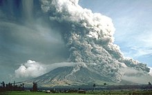
Mount Mayon in eruption on July 21, 1928.
Mayon Volcano's longest uninterrupted eruption occurred on June 23, 1897 which lasted for seven days of raining fire. Lava once again flowed down to civilization. Seven miles eastward, the village of Bacacay was buried 15 m (49 ft) beneath the lava. In Libon 100 people were declared dead—incinerated by steam and falling debris or hot rocks. Other villages like San Roque, Misericordia and Santo Niño became deathtraps. Ash was carried in black clouds as far as 160 km (100 mi) from the catastrophic event, which killed more than 400 people.[6]
Samuel Kneeland, a professor and a geologist had observed the volcanic activity five months before the eruption:
At night the scene was truly magnificent and unique. At the date of my visit the volcano had poured out...a stream of lava on the Legaspi side from the very summit. The viscid mass bubbled quietly but grandly, and overran the border of the crater, descending several hundred feet in a glowing wave, like red-hot iron. Gradually, fading as the upper surface cooled, it changed to a thousand sparkling rills among the crevices, and, as it passed beyond the line of complete vision behind the woods near the base, the fires twinkled like stars, or the scintillions of a dying conflagration. More than half of the mountain height was thus illuminated.[9]
Mayon Volcano on September 23, 1984
No casualties were recorded from the 1984 eruption after more than 73,000 people were evacuated from the danger zones as recommended by PHIVOLCS scientists.[10] But in 1993, pyroclastic flows killed 77 people, mainly farmers, during the eruption.
Its 48th eruption was a quiet effusion of lava on July 14, 2006,[11] which was aggravated when a lahar caused by the rains of Typhoon Durian followed on November 30, 2006. The small activities from 2003 and 2004 are considered as precursors to the 2006 eruption. The small summit explosion which occurred on August 10, 2008 is considered as part of the ongoing activity since 2006.[7] Starting in January 2011, the volcano is weakly erupting and may be building up to a larger hazardous eruption.

[edit] 2006 eruption

Mayon erupted again from July to October 2006, with no apparent loss of life during the actual eruption period.
  • August 7, 2006: The Philippine government ordered the evacuation of about 20,000 people living near the volcano, stating that an eruption was feared soon.[12] Volcanologists have detected 21 low-frequency volcanic earthquakes since early Sunday morning.[13]
  • August 8, 2006: The government expected to move some 34,276 people to 31 state-run shelters and warned that the mountain could explode at any time.[14][15]
Mayon Volcano in satellite image.
  • August 9, 2006: Volcanologists warned that Mount Mayon could explode at any time but that the gravitational pull of a full moon could provide the final push. A full moon coincided with at least three of Mayon’s nearly 50 explosions over the last four centuries, including the two most recent in 2000 and 2001. Nearly 40,000 people have been moved from an 8 km (5 mi) danger zone on the southeast flank of the volcano, which has been quaking and spitting plumes of ash since July.[16]
  • August 10, 2006: Scientists in the Philippines renewed warnings of a major explosion at the Mount Mayon volcano, describing a sudden period of quiet as "ominous". A drop in gas emissions and earthquakes sparked fears that the crater had plugged itself, increasing the likelihood of an explosive eruption.[17]
  • August 11, 2006: Scientists said ground surveys showed Mayon was still "swollen" and registered a high number of volcanic earthquakes, emitted large amounts of sulfur dioxide gas and continued to eject lava down its slope nearly four weeks after it came to life in a "quiet" eruption on July 14.[18]
Phivolcs maintained threat level at Alert Level 4 for the next month because of the continued extrusion of lava, ash explosions, steam and smoke plumes, seismic activity, and threat of further eruption.
  • September 11, 2006 Phivolcs downgraded threat level to Alert Level 3. "After the ash explosion of September 1, a general decline in the overall activity of Mayon has been established. The decrease in key parameters such as seismicity, gas (Sulfur Dioxide) emission rates and ground inflation all indicate a waning condition. The slowdown in the eruptive activity is also evident from the decrease in intensity of crater glow and the diminishing volume of lava being extruded from the summit".[19]
  • October 3, 2006 Phivolcs downgraded threat level to Alert Level 2. "All monitored key parameters such as earthquake levels, ground deformation and gas outputs further declined. In addition, lava extrusion apparently ceased on October 1, 2006 as reported by Ligñon Hill Observatory. The above observations indicate the absence of an intruding new mass of magma."[20]
  • October 25, 2006 Phivolcs downgraded threat level to Alert Level 1 (no hazardous eruption imminent).[21]

[] 2008 eruption

On August 10, 2008, a small summit explosion ejected ash 200 metres (660 ft) above the summit, with the ash drifting east northeast. In the weeks prior to the eruption,[22] there was a visible glow within the crater and increased seismicity.[23]

[] 2009–2010 eruption

On July 10, 2009, PHIVOLCS raised the status from Alert Level 1 (low level unrest) to Alert Level 2 (moderate unrest) because the number of recorded low frequency volcanic earthquakes rose to the same level when a phreatic explosion occurred last August 2008.[24][25]
At 5:32 am Wednesday October 28, 2009, a minor ash explosion lasting for about one minute occurred in the summit crater. A brown ash column rose about 600 metres (2,000 ft) above the crater and drifted toward the northeast. In the prior 24 hours, 13 volcanic earthquakes were recorded. Steam emission was at moderate level, creeping downslope toward the southwest. PHIVOLCS maintained the Alert Status at Level 2, but later warned that with the approach of tropical cyclone international codename Mirinae the danger of lahars and possible crater wall collapse will greatly increase and all specified precautions should be taken.[26]
At 1:58 am Wednesday November 11, 2009, a minor ash explosion occurred at the summit crater lasting for about three minutes. This was recorded by the seismic network as an explosion type earthquake with rumbling sounds. Incandescent rock fragments at the upper slope were observed in nearby barangays. Ash column was not observed because of cloud cover. After dawn, field investigation showed ashfall had drifted southwest of the volcano. In the 24 hour period, the seismic network recorded 20 volcanic earthquakes. Alert Status was kept at Level 2 indicating the current state of unrest could lead to more ash explosion or eventually to hazardous magmatic eruption.[27]
Mayon Volcano with ash explosion at dawn on December 18, 2009
At 8 pm on Monday December 14, 2009, as a result of 83 volcanic quakes in the preceding 24 hours[28] and increased sulphur dioxide emissions, Phivolcs raised the Alert status to Level 3.[29]
Early in the morning of Tuesday December 15, 2009, a moderate ash explosion occurred at the summit crater and "quiet extrusion of lava" resulted in flows down to about 500 metres from the summit of Mayon.[30] By Tuesday night Albay Province authorities were reported to have moved about 20,000 residents out of the eight kilometre danger zone and into local evacuation centres. About 50,000 people were said to live within the eight kilometer zone.[31][32]
On December 17, 2009, there were five ash ejections with one reaching 500 meters above the summit, sulphur dioxide emission increased to 2,758 tonnes per 24 hours, lava flows reached down to 1500 metres below the summit, and incandescent fragments from the lava pile continuously rolling down Bonga Gully reached a distance of 3 to 4 km below the summit. By midday December 17, a total of 33,833 people from 7,103 families had been evacuated, 72 percent of the total number of people that needed to be evacuated, Albay Governor Joey Salceda was reported to have said.[33]
On December 20, 2009, PHIVOLCS raised Mayon's status level to alert level 4 because of an increasing lava flow in the southern portion of the volcano and an increase in sulphur dioxide emission to 750 tonnes per day. As well, almost 460 earthquakes in the volcano were monitored everyday. In the border of danger zone, rumbling sounds like thunder were also heard. Over 9,000 families (44,394 people) were evacuated by the Philippine government from the base of the volcano.[34] No civilian was permitted within the 8 kilometer danger zone, which has been cordoned off by the Philippine military, who were actively patrolling within the danger zone to enforce the "no-go" rule and to ensure no damage or loss of property of those evacuated.[35]
Mayon Volcano in eruption on December 29, 2009.
Alert level 4 was maintained as the volcano remained restive through the month of December, prompting affected residents to spend Christmas and the New Year in evacuation centers.[36] On December 25, sulfur dioxide emissions peaked at 8,993 tons per day.[37][38] On December 28, PHIVOLCS director Renato Solidum commented on the status of the volcano, "You might think it is taking a break but the volcano is still swelling."[35] On the next day December 29, a civil aviation warning for the airspace near the summit was included in the volcano bulletins.[39] The ejected volcanic material since the start of the eruption was estimated to have been between 20 million to 23 million cubic meters of rocks and volcanic debris, compared to 50 million to 60 million cubic meters in past eruptions.[40]
On January 2, 2010, PHIVOLCS lowered the alert level of the volcano from level 4 to level 3, citing decreasing activity observed in the past four days.[41] The state agency noted the following observations as a trend of decreasing activity: absence of ash ejections and relative weakness of steam emissions, majority of earthquakes caused by rockfalls and rolling fragments, and gradual decrease in sulfur dioxide emissions from a maximum of 8,993 tons per day to 2,621 tons per day.[38] 7,218 families within the seven-kilometer to eight-kilometer danger zones were allowed to return to their homes, while 2,728 families who live in the four-kilometer to six-kilometer danger zones would have to stay in the evacuation centers pending the PHIVOLCS decision to further lower the alert level.[42]
On January 13, 2010, PHIVOLCS reduced the alert level from 3 to 2, saying that this indicated a further reduction in the likelihood of hazardous eruption.[43]

[] Government response

Map showing major volcanoes of the Philippines
Albay governor Joey Salceda declared the disaster zone an 'open city' area to encourage aid from external groups. Potential donors of relief goods were not required to secure clearance from the Provincial Disaster Coordinating Council, but were able to directly coordinate with support groups at the local government level.[44]
The restiveness of the volcano also stimulated the tourism industry of the province. Up to 2,400 tourists per day have arrived in the area since the volcano started erupting on December 14, filling local hotels, compared to about a more modest average of 200 in the days prior. However it was reported that some tourists lured by local "guides" might be ignoring government warnings not to venture into the 8-kilometre (5.0 mi) danger zone. "It's a big problem. I think the first violation of the zero casualty (record) will be a dead tourist," said Salceda.[45]
Speaking about thrill-seekers finding their way in to the area, Salceda warned, "At the moment of the eruption, the local guides will have better chance of getting out. The hapless tourist will be left behind."[45]

[] International response

Following the declaration of alert level 3 for the volcano, the United States issued an advisory cautioning its nationals from traveling to Mayon. Canada and the United Kingdom also posted advisories discouraging their nationals from visiting the volcano.[46]
The United States government has committed $100,000 in financial aid for the evacuees of Mayon Volcano. In cooperation with the Philippine government the assistance will be delivered through the Philippine National Red Cross and other NGOs by USAID.[47]
The Albay provincial government has ordered the local military to add more checkpoints, place roadblocks and arrest tourists caught traveling inside the eight-kilometer danger zone.[48]
Power and water supply were cut off within the danger zone to further discourage residents from returning. The Commission on Human Rights has allowed the use of emergency measures and has given the authorities clearance to forcibly evacuate residents who refuse to leave.[49]
When the alert level around the volcano was lowered from alert level 4 to alert level 3 on January 2, 2010, the Albay provincial government ordered a decampment of some 47,000 displaced residents from the evacuation centers.[50] Power and water supply in the danger zones were restored.[36] Military vehicles were used to transport the evacuees back to their homes, while food supplies and temporary employment through the Department of Social Welfare and Development (DSWD) were provided to the heads of each family.[50][51] As of January 3, 2010, the National Disaster Coordinating Council reported the overall cost of humanitarian aid and other assistance provided by the government and non-government organizations (NGOs) has reached over 61 million pesos since the start of the eruption.[52]
The United Nations World Food Programme (UN-WFP) has delivered 20 tons of high energy biscuits to the evacuees to complement supplies provided by the DSWD, with more to be allocated from emergency food stocks intended for relief from the effects of the 2009 Pacific typhoon season.[53] When the alert level was downgraded to level 3 on January 2, 2010, UN-WFP provided three days worth of food for evacuees returning to their homes who will continue to receive supplies already set aside for them.[41]

[] Devastating lahars following eruptions and typhoons

The church tower is what remains of the Cagsawa Church, which was buried by the 1814 eruption of Mayon Volcano. It withstood the damage done by Typhoon Durian in 2006.
Following the eruption of 2006, on November 30 of that year, strong rainfall which accompanied Typhoon Durian produced lahars from the volcanic ash and boulders of the last eruption killing at least 1,266 people. The precise figure may never be known since many people were buried under the mudslides.[4] A large portion of the village of Padang (an outer suburb of Legazpi City) was covered in mud up to the houses' roofs.[54][55] Students from Aquinas University in Barangay Rawis, also in Legazpi, were among those killed as mudslides engulfed their dormitory. Central Legazpi escaped the mudslide but suffered from severe flooding and power cuts.
Parts of the town of Daraga were also devastated, including the Cagsawa area, where the ruins from the eruption of 1814 were partially buried once again. Large areas of Guinobatan, Albay were destroyed, particularly Barangay Maipon.
Similar post-eruption lahar occurred in October 1766, months after the July eruption of that year. The heavy rainfall also accompanying a violent typhoon carried down disintegrated fragmental ejecta, burying plantations and whole villages. In 1825, the event was repeated in Cagsawa killing 1,500 people.[56]

[] Monitoring Mayon

Mayon Volcano is the most active volcano in the Philippines, and its activity is regularly monitored by PHIVOLCS from their provincial headquarters on Lignon Hill, about 10 kilometres (6.2 mi) SSE from the summit.
Three telemetric units are installed on Mayon's slopes, which send information to the seven seismometers in different locations around the volcano. These instruments relay data to the Lignon Hill observatory and the PHIVOLCS central headquarters on the University of the Philippines Diliman campus.
PHIVOLCS also deploys electronic distance meters (EDMs), precise leveling benchmarks, and portable fly spectrometers to monitor the volcano's daily activity.
ayon Volcano is the main landmark of Albay Province, Philippines, rising 2,462 metres (8,077 ft) from the shores of the Gulf of Albay